


Scientists Predict a “Super El Niño”–But wait, what’s that?
Climate.gov
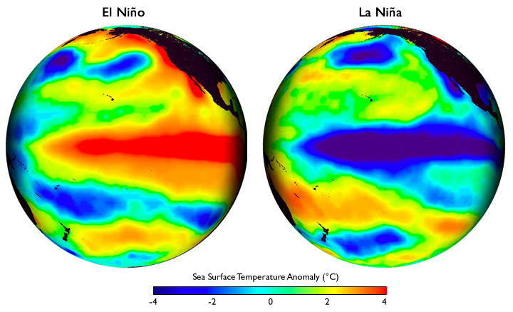
Patterns of sea surface temperature during El Niño and La Niña episodes
This year, in my AP Environmental Science class, I’ve learned about a weather phenomenon involving changing wind patterns and ocean surface temperatures called La Niña and El Niño. It is a process that causes shifts in rainfall, wind, and sea circulation patterns in equatorial sea regions that have varied impacts depending on geographic location. It can be a confusing concept (I, in part, decided to write this article to brush up on the concept before the exam), but I’m here to explain it the best I can.
Before diving into these two specialty conditions, let’s first go over what a typical year looks like regarding weather patterns. Usually, Eastern trade winds blow water along the equator from East to West, and water gets upwelled (meaning colder water gets drawn up to the surface as warm surface waters are blown away) off of the coast of South America. Cold water would be optimal for fisheries and higher pressure in the East Pacific (the Americas) and heat, precipitation, and low pressure in the West Pacific (towards Australia and Southeast Asia).
A fundamental way of seeing a La Niña event is that the patterns in an average year are amplified. The trade winds are more robust than expected, increasing upwelling off the South American coast. There are also more extreme weather events that differ depending on the region of the world; increased tornado activity in the United States, hurricane activity in the Atlantic, monsoons in Southeast Asia, and overall cold and dry conditions in the East Pacific, while the opposite goes for the West Pacific. We (in the East Pacific) have been experiencing La Niña conditions, including tornados across the midwest, east coast hurricanes, and snow in the west. However, scientists report that this La Niña event has ended after a whopping 3 years, and in its wake, they are seeing signs of a “super El Niño” event in the coming year.
So what is an El Niño event?
Short answer: the opposite of La Niña. Also known by its longer name, El Niño Southern Oscillation, it is characterized by the weakening and possible reversal of the trade winds. This change in wind magnitude and direction causes low pressure and warm currents to make their way to the Eastern Pacific, suppressing upwelling and causing higher temperatures and precipitation in this region. Meanwhile, as expected, the opposite occurs in the West Pacific: cool, dry conditions and high pressure. In terms of extreme weather, this event actually decreases hurricane activity in the Atlantic and monsoon activity in India and Southeast Asia, but the increased precipitation in the Americas causes flooding, especially around the West Coast.
What does this “super El Niño” mean for us (again, on the Eastern Pacific)?
A CNN article outlines 6 possibilities to look out for due to a strong El Niño. 1) A 1.5 degrees Celsius rise in global temperature— a record-high warming increase that sets a precedent for “extreme flooding, drought, wildfires, and food shortages.” Yikes. 2) Increased rain on the West Coast (as if we need more), bringing threats of “flooding, landslides, and coastal erosion.” 3) Drought, heat, and fire on the other side of the Pacific cause water insecurity, dangerous heat waves, and bushfires. 4) Strong tropical cyclones from warmer ocean water. 5) Detrimental reef bleaching from warm waters outside the tolerance range of coral, destroying their symbiotic relationship with algae, their life source. And finally, to top it all off, 6) The quickening rate of Antarctic ice melting can result in catastrophic global sea level rise.
El Niño and La Niña are naturally occurring events, meaning humans cannot influence or prevent them from happening. However, there are ways that anthropogenic (human-caused) global warming could affect the frequency and intensity of El Niño/La Niña, though scientists cannot yet predict what the exact ramifications or extreme weather events are.

Kana is a senior at GALA and is excited and honored to be The Echo's Editor-In-Chief this year. Her goal is to ensure that news in all sections of The...